Eastside

Summary

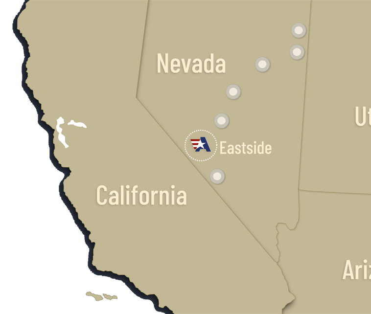
Allegiant owns 100% of the district-scale Eastside Gold-Silver project located 35km from the town of Tonopah in mining friendly Nevada, one of the world’s top mining jurisdictions.

The project has outstanding infrastructure for mining with a high-voltage power line passing through the northern boundary of the property and highway US 95 through the southern boundary. Preliminary metallurgical testing indicates that gold at Eastside is amenable to cyanide leaching for both oxide and sulfide mineralization.
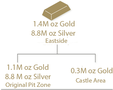
Inferred gold and silver resources have been defined at the Original Zone, which remains open to the south, west and at depth, and possibly to the north and east. The southern margin of the property also hosts historical near surface oxide gold resources. To date, seven (7) large geochemical anomalies have been identified on the property. In addition, ALLEGIANT has identified 314,000 inferred gold ounces at the Castle Area in the south of Allegiant with potential for increased resource expansion.

ALLEGIANT plans to drill over 20,000 meters in the second half of 2021 and first half of 2021 to test the recently discovered high-grade zone within the western edge of the Original Pit Zone and to test additional targets to the west, east and south of the Original Pit Zone.

Resource Estimate
Drill results
Maps
Gallery
X-Sections (17MB)

Geology

Solid Infrastructure, history of success

In the Monte Cristo Range, including the area of the Eastside project, volcanic and associated volcanic sedimentary rocks of Cenozoic ages overlie Paleozoic marine chert, shale, siliceous argillite, siltstone, fine-grained quartzite, and lesser limestone. The Cenozoic rocks include (1) Oligocene and Miocene ash flow tuffs (24 to 26.7 Ma); (2) andesite flows, tuffs, dacite flows, and intrusive rocks of the Blair Junction sequence (15.7 to 22.2 Ma); (3) fresh-water lake sediments of the McLeans unit; (4) Gilbert Andesite (15 Ma) and (5) a series of rhyolite domes, associated rhyolite tuffs, and basaltic lava flows (7.2 Ma). Of particular importance are the 7.2 Ma high-level rhyolite domes, plugs and related pyroclastic deposits which host most of the gold and silver resources at the Eastside project.

More

EXPLORATION

  • 2017-18: 8,279 meters (27,162 feet)
  • 2016 (2016): 17,500 meters (57,413 feet), including:
    • 12,663 meters (41,544 feet) of rotary drilling, and
    • 4,837 meters (15,869 feet) of core drilling
  • 2015 (Phase IV): 12,298 meters (40,347 feet)
  • 2013 (Phase III): 2,944 meters (9,715 feet)
  • 2013 (Phase II): 2,391 meters (7,890 feet)
  • 2011 (Phase I): 2,215 meters (7,405 feet)


More

Resources

The Eastside Gold Project hosts a NI 43-101 Inferred Resources at the Original Zone located in the northern part of the property and remains open to the south, to the west and at depth.  Eastside also contains Historical Resources at the Castle Zone located at the southern boundary of the property.   Seven additional high priority targets have been identified and a Phase I drill program at Target 5 was initiated March 7, 2017.

More

Resource Center

Learn more about Eastside

Subscribe to our Email List